EXECUTIVE SUMMARY
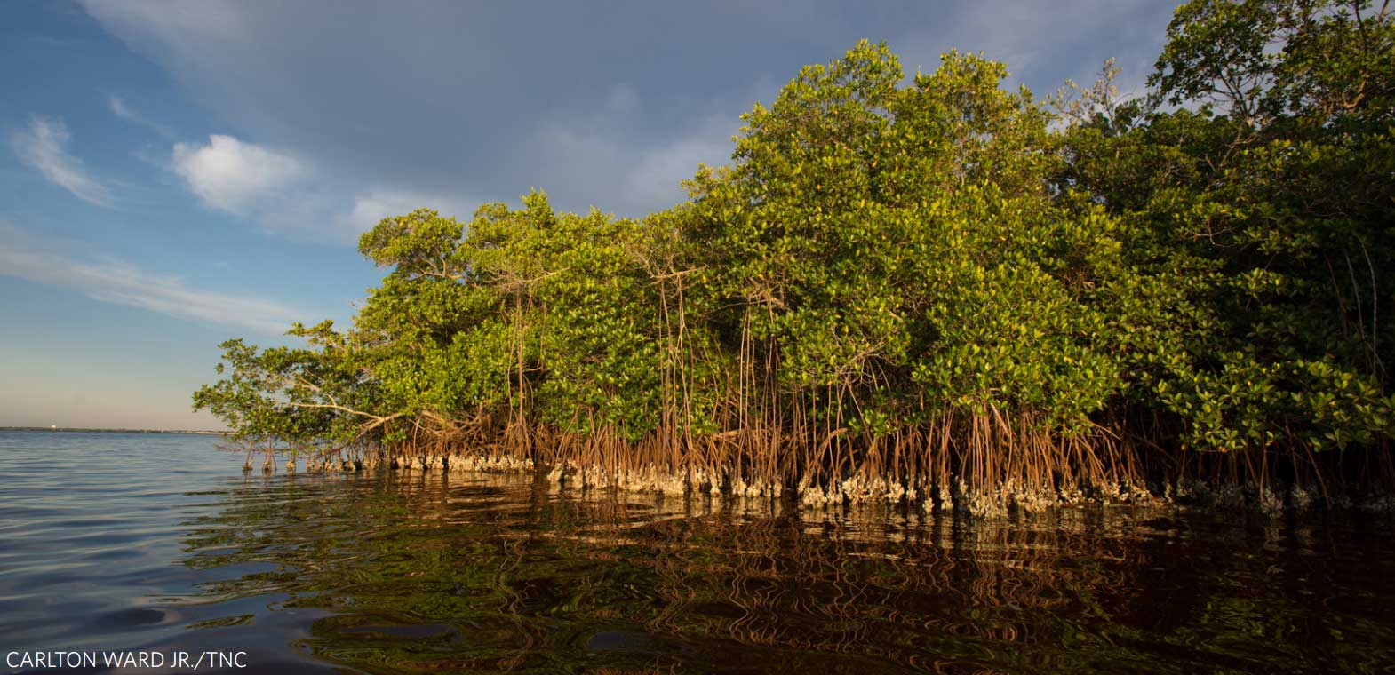
Coastal risks are rising and at the same time we are losing coastal habitats, like mangroves, which can function as a first line of defense for coastal communities. In this study, we used an insurance industry catastrophe model to quantify the economic benefits of mangroves in Florida for reducing coastal flood damages annually in Collier County and from Hurricane Irma, which impacted Florida statewide in 2017. To quantify the value of mangroves in reducing average annual property losses in Collier County, we modelled annual surge-related losses under two scenarios: ‘With Mangroves’ and ‘Without Mangroves’. The difference in losses between the two scenarios represents the averted damages (i.e., benefits) provided by current mangroves. To quantify the flood damage reduction benefits of mangroves during Hurricane Irma we similarly estimated surge-related losses during the event for the two mangrove scenarios. To quantify surge-related flooding and losses, we first estimated storm-surge flooding (extents and heights) from each coastal storm by coupling a parametric hurricane wind-field model with a 2-D hydrodynamic flood model. The physical effect of mangroves on flood reduction was represented using a friction coefficient within the flood model. Flood damages were then estimated by combining the flood extents with an extensive property exposure and damage database. We also estimated the number of people that benefitted from flood reduction by mangroves using public census datasets. The results of this work show that mangrove forests in Florida provided significant flood damage reduction benefits annually, across multiple storms, and during catastrophic events like Hurricane Irma. In Collier County, mangroves reduced annual flood risk by 25.5% to properties behind them. Many areas in the county received over $1 million in benefits every year in flood damage reduction benefits due to the mangroves in front of them. The value of mangrove forests during Hurricane Irma was also very high. Mangroves averted $1.5 billion in storm damages, amounting to a 25% savings in counties that have mangroves. They also protected more than 626,000 people across Florida. Not surprisingly, some of the highest % benefits occurred in areas where there are larger swaths of mangroves remaining and moderate development. Nonetheless,
significant benefits did occur in areas where only small belts of mangroves remain in some of the densest urban corridors. Most of the estimated benefits of mangroves during the Hurricane Irma surge were concentrated in regions of southeast and southwest Florida that have a unique combination of large mangrove extents in front of high densities of people and properties. Almost all of this risk reduction took place in Lee and Collier counties, where Irma made landfall on the mainland. In these counties, mangroves are predicted to have reduced damages to properties during the hurricane by over $1.2 billion. There are some areas where mangroves potentially increased flooding and flood losses, for properties that were built seaward of these natural defenses. Overall, we found that the flood reduction benefits of mangroves are substantially higher than the benefits of salt marshes in the northeast that we found in a prior study using similar models (Narayan et al., 2017). These findings show that it is important to properly account for coastal habitats like mangroves within flood risk models in order to properly characterize coastal risks to people and property. The findings of this study make a strong economic case for protecting Florida’s remaining mangroves and restoring mangrove areas as a risk reduction strategy. The results point to the high value of mangroves as natural capital and national risk reduction infrastructure both in tropical areas where they already exist and in more temperate regions across the Gulf of Mexico where mangroves are currently expanding their range. The flood reduction benefits of mangroves are sizeable enough to inform habitat restoration priorities and nature-based risk reduction strategies. These opportunities could include pre-hazard mitigation and disaster recovery spending on mangroves, green municipal bonds to fund restoration, and potential premium reductions from public and private insurance plans for mangrove conservation and restoration.
INTRODUCTION
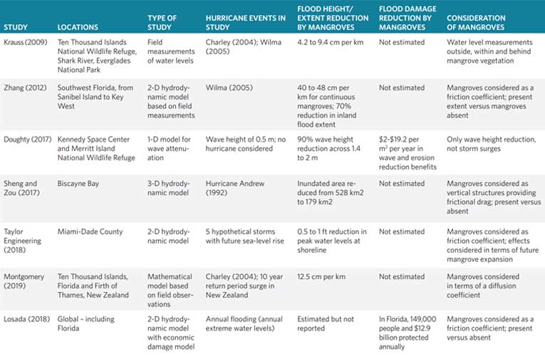
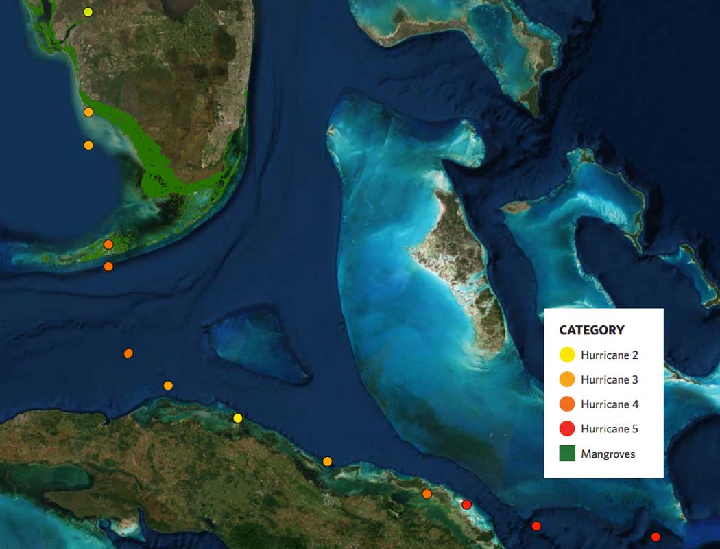
Coastal flooding causes significant economic damage in the US and globally. Hurricanes Irma and Harvey, which occurred in 2017, devastated islands and nations in the Caribbean and could cost the US in excess of $200 billion in damages (Blake, 2018). Hurricane Irma caused extensive flooding and damage when it made landfall twice in the state of Florida. It contributed to one of the costliest years on record for the US in terms of hurricane-related flooding and damages, with initial economic damage estimates at around $50 billion. The hurricane caused storm surges of three to ten feet in the lower Keys, along Biscayne Bay, and along the southwestern coastline, though offshore winds on its northern side initially caused a depression in water levels along Florida’s west coast. Some of the highest storm surges of eight to ten feet were observed along the mangrove dominated coastline of the Everglades National Park (Cangialosi et al., 2018). States like Florida on the US Gulf Coast are particularly vulnerable to storm surges due to high frequency of hurricanes, subsidence and rising sea levels (Hauer et al., 2016). As the likelihood and costs of flood damage from hurricanes continue to rise, there is increasing pressure on local communities to identify cost-effective strategies for reducing their flood risk (Lincke and Hinkel, 2018). Traditionally, coastal development in hurricane-prone areas is accompanied by the building of artificial barriers to protect people and assets from flooding, often at the expense of natural ecosystems. Protective structures like storm surge barriers, seawalls and levees are costly to build and will become increasingly difficult to maintain as sea-levels rise (Aerts, 2018). Once built, coastal structures often disrupt the natural coastal environment, and can degrade and limit the extent of coastal ecosystems (Gittman et al., 2016). In addition to losing biodiversity, this degradation of ecosystems can aggravate coastal risks and adversely affect the resilience of vulnerable communities (Sutton-Grier et al., 2018). This is also true in Florida where rapidly growing coastal populations and urban development have considerably increased the risks of flooding from hurricanes while simultaneously contributing to the degradation of the natural mangrove ecosystems that provide valuable protection to people and property on these coastlines (Brody et al., 2015, 2007). Mangrove forests have been shown to be particularly important as coastal defenses in Florida (Table 1). There is strong evidence globally to show that natural habitats like mangrove and marsh wetlands can play a significant role as first lines of defense against these hazards (Cheong et al., 2013; Hochard et al., 2019; Losada et al., 2018). By stabilizing the coastline, building land elevations and acting as obstacles to storm waves and surges, they can play a significant role in protecting vulnerable people and property on coastlines (Duarte et al., 2013; Pinsky et al., 2013; Shepard et al., 2011). More importantly, they can reduce flood extents and therefore damages from storm surges and extreme water levels (Dasgupta et al., 2019; Menéndez et al., 2018; Wamsley et al., 2010). Yet, these natural habitats are in constant conflict with other land-uses in the state. Despite the growing evidence of their benefits, the conservation, restoration and management of mangroves and similar ecosystems as risk reduction measures is still uncommon (Beck and Lange, 2016; Narayan et al., 2016; Temmerman et al., 2013). Quantifying the economic benefits of coastal ecosystems during extreme events is essential for demonstrating their value as natural coastal defenses along risky coastlines (e.g., Reguero et al., 2019). Understanding where and how the physical effects of mangroves on extreme water levels translate to risk reduction benefits to people, property and infrastructure is crucial to understanding the economic value of protecting, conserving and restoring these ecosystems. However, there has been little large-scale quantitative analysis of the economic contribution of mangroves to reducing coastal flooding risks, and industries with interests in coastal property risk – such as insurance or real estate development – need this information to price in the effect of mangroves on flood risk. We aim to fill this knowledge gap by using a catastrophe modelling approach to quantitatively estimate the economic impacts of mangroves on flood damages to coastal properties in Florida. In the process, we aim to show that catastrophe modelling can be effectively used to assess the impacts of mangrove forests on flood risks to people and property. Catastrophe modelling offers a powerful framework to estimate the economic damage caused to property from extreme events such as tropical cyclones. Such models are routinely used in the insurance industry globally to help insurers and reinsurers price and manage catastrophe risk (Mitchell-Wallace et al., 2017). Generally speaking, catastrophe models characterize the distribution of loss from catastrophic events (such as hurricanes) by generating a very large set of synthetic events which span the realm of the physically possible storms in that region. They simulate the physical (i.e. coastal flood) effects of each event on a given geographic area, and then calculate the resultant economic damage caused by each event to a portfolio of properties via damage functions that are appropriate for the flooded properties (LMA, 2015). In addition, catastrophe models can be used to simulate the economic damage from specific historical events by reconstructing the parameters associated with these events. We used an insurance industry catastrophe model, comprising a parametric windfield model coupled with a 2-D hydrodynamic flood model, and a loss model that uses a comprehensive property exposure database to estimate the risk reduction benefits of mangroves in Florida. These benefits were estimated i) annually, across multiple storms, at the county scale and ii) statewide during a surge event based on Hurricane Irma. The flood and loss models, from Risk Management Solutions (RMS), are commonly used throughout the insurance industry, including by many of the world’s largest insurers and reinsurers, and have previously been used and described in studies on predicting hurricane landfalls in the US (Coughlin et al., 2009), estimating surge-related flooding from these hurricanes (Hsiang et al., 2017) and measuring the impact of marsh wetlands on flood damages from storm surges (Narayan et al., 2017). In this study, we first estimated the annual economic benefits of mangroves for Collier County in southwest Florida in terms of avoided flood damages to coastal and inland properties across 100 storms representative of possible storms in the region. Next, we quantified the economic value of mangroves across Florida in avoided flood damages from a surge event based on Hurricane Irma. While the surge event was modelled based on Hurricane Irma’s storm parameters (i.e. track, forward movement, wind-fields) we note that this is not an official RMS reconstruction of Hurricane Irma. For both studies, the benefits of mangroves were estimated by comparing flood extents and damages for a baseline scenario with the present extent of mangroves and for a hypothetical scenario without mangroves. The difference in surge-related property losses between the two scenarios represents the avoided flood damages (i.e., benefits) provided by current mangroves.
METHODS
The methodology for estimating the risk reduction benefits of mangroves follows a series of steps that are standard practice in catastrophe risk and coastal engineering assessments and follows the recommended methodology for national valuations of natural capital by the World Bank (Beck & Lange, 2016). Annual benefits in Collier County To estimate annual mangrove benefits for flood reduction in Collier County, we quantified the impacts of mangroves across a stochastic set of 100 hypothetical storm events that are representative of the complete distribution of storms for the region (see Technical Appendix). We selected these 100 storm events from a larger set of ~4000 storm events purpose-built for the region, to provide a representative picture of annual flood probabilities for Collier County. This representative event set is built by splitting the full storm event set into 100 return-period classes and selecting, from each class, the event that is most representative of the average loss across all events in that class. The resulting stochastic set of 100 storm events is within 0.05% of the annual loss from the full event set. For each of these 100 events, flood footprints were created using the RMS flood model for both a scenario with mangroves and a scenario without mangroves (i.e. a total of 200 flood footprints). Then, the RMS loss model was used to estimate property damages for each flood event. The loss values for all 100 events along with information on their annual frequencies were used to estimate the annual average flood losses for the two mangrove scenarios (with and without mangroves). The differences between these losses represent the annual risk reduction benefits of mangroves across the county. Maps of spatial variation in annual losses across Collier County were created by aggregating damages into hexagonal units of uniform area (5 km2 ) for clarity and ease of viewing. All analyses were done using ArcGIS v10.4.1 and RStudio v1.01.136 software. All losses were estimated in terms of 2018 US dollars.
Benefits during Hurricane Irma
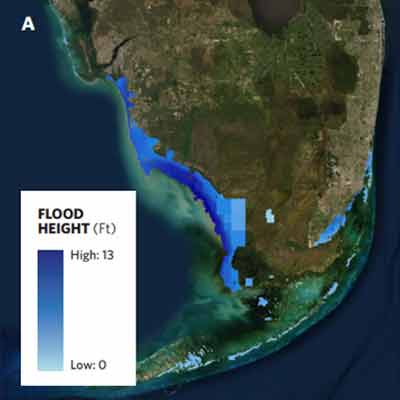
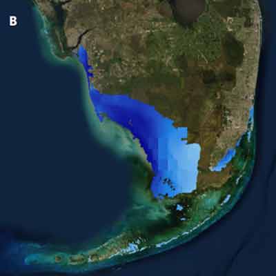
To estimate mangrove benefits during an extreme hurricane event, we applied this process to model the storm surge from an event based on Hurricane Irma (Figure 1; see Technical Appendix). Using observational data on various parameters during the Hurricane, including hurricane track, forward speed, air pressure, and wind-speeds, we reconstructed offshore wind-fields and offshore water level boundary conditions. These offshore conditions drive the storm surge model to simulate the flood footprint due to the hurricane. This flood footprint represents flooding with current mangroves intact. We then recalculated these flood footprints for a scenario with all coastal mangroves converted to open water which provides lower roughness. This scenario removes the impact of mangroves and allows us to calculate the flood footprint without mangroves. We then estimated the flood damages for both these flood footprints (with and without mangroves), with the difference providing the flood damage reduction of the intervening mangroves. Maps of spatial variation in losses across the state were created by aggregating damages into hexagonal units of uniform area (5 km2) for clarity and ease of viewing.
RESULTS
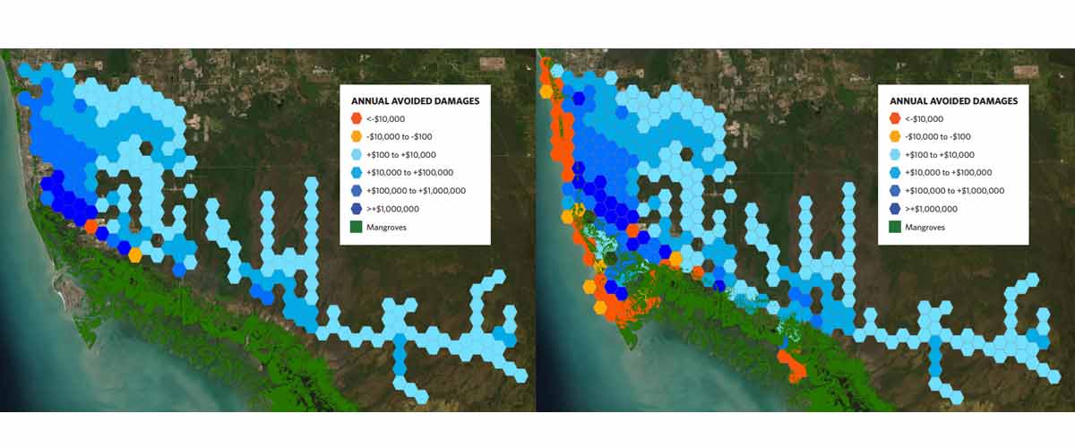
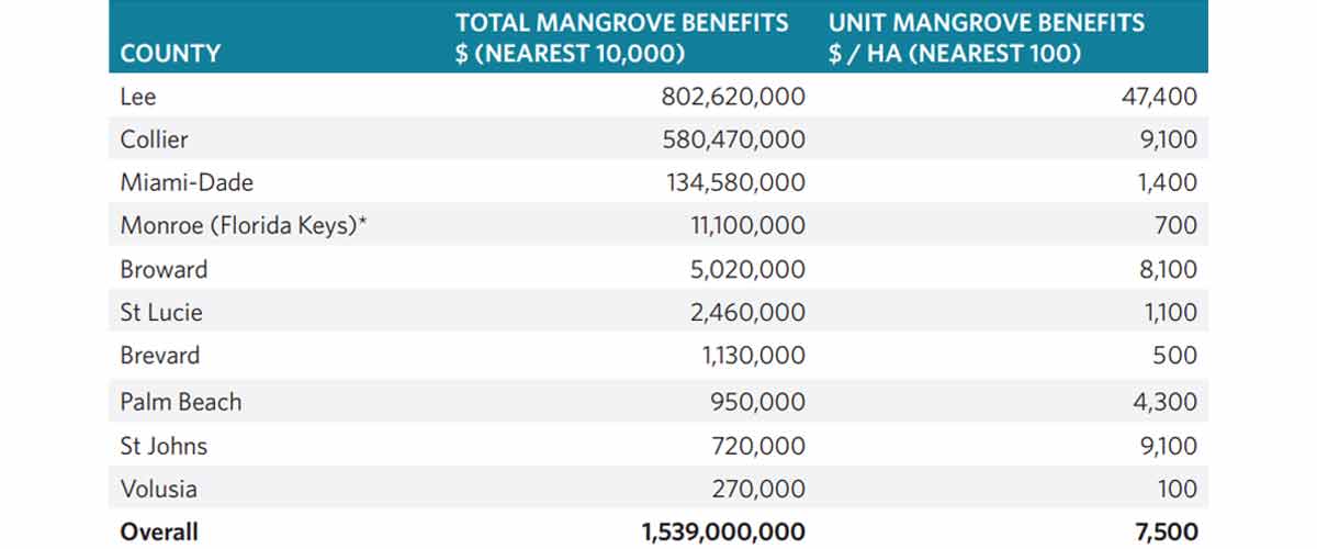
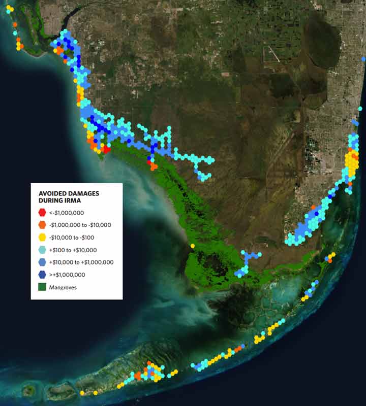
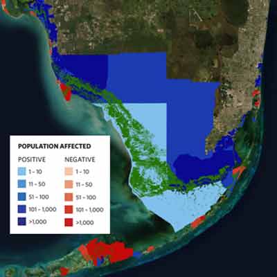
In Collier County, mangroves reduce average annual flood losses to properties behind by 25.5% which translates to an average benefit of $540 per hectare per year across these properties (Figure 2). However, some of the highest-value properties in the county are located within and in front of these large mangrove extents, where the flood reduction impacts of the mangroves are more mixed (Figure 3). Some regions immediately behind the county’s mangroves (i.e. deep blue hexagons in Figure 3) receive annual risk reduction benefits over $1 million. Other regions where development has occurred in front of, or within these mangroves, see an increase in flood damages due to being located between a body of water and mangroves (red and orange hexagons in Figure 3). During Hurricane Irma, flooding from the storm surge would have increased by more than 3,200 hectares in the absence of mangroves across the state (Figure 4). By reducing the extent and depth of the flooding footprint, mangroves prevented over $1.5 billion in property damages (Table 2). This amounts to a savings in flood damages of nearly 25% in counties with mangroves. Excluding the mangroves of the Everglades National Park, where there is very little human presence, the average value of Florida’s mangroves for risk reduction during Hurricane Irma is predicted to have been more than $7,500 per hectare. The effect of mangroves on flood damages was spatially variable; mangroves offered the greatest benefits where mangroves were abundant and in front of areas with high densities of people and property (Figure 5). The counties that benefited the most from the presence of mangroves during Hurricane Irma were Lee and Collier Counties on the Gulf Coast – closest to where Hurricane Irma made landfall on the mainland and where the surge was the greatest (Table 2). In Miami-Dade, swathes of urban coastal mangroves protected high-value coastal properties from flood damages of over $130 million. In Monroe County, across the Florida Keys, mangroves provided, on average, $700 per hectare in risk reduction benefits during the hurricane. Broward County and St. John’s County further north saw much larger benefits from their mangroves due to high densities of coastal properties protected by relatively smaller extents of mangroves. Mangroves reduced flooding and flood damages in most locations and had a negative effect (i.e. increased flooding) in a few locations where properties were built within or in front of the mangroves. As with many coastal structures such as seawalls, mangrove forest belts act as barriers or baffles, increasing surge water levels immediately seaward of the belt and decreasing water levels behind it (Figure 5). In Collier County, development on the seaward side of mangroves experienced an increase in flooding. We observed a similar effect within an estuarine patch of mangroves in Miami-Dade County where the presence of these mangroves increased water levels and flood damages for properties in front of them (Figure 3; yellow and orange hexagons in Miami-Dade). However, these same mangroves reduced losses during this storm by $88 million for properties behind them, just to the north (Figure 3; blue hexagons in Miami-Dade). Due to these effects, around 95,000 people living in a narrow coastal band in front the mangrove forests experienced higher flooding during the hurricane. While this number is small (15%) in comparison to the number of people who benefited from mangroves, it is important to note that the effects of mangrove forests on flooding are not positive everywhere, which is largely dependent on development choices. Looking beyond only economic damage, mangroves also reduced flooding for over half a million people across southern Florida, during this hurricane. This effect is again highest in the densely populated coastal areas of southwest Florida and Biscayne Bay (Figure 6). The loss of mangrove forests across Florida would result in over 626,000 more people being flooded during the hurricane. Similar to property values, the effect of mangroves on people living in front of these forests were mixed: mangroves increased flooding to around 95,000 people during the hurricane. Critically, some of these mangroves protect socially vulnerable coastal populations: they reduced flooding for around 104,000 people living below the poverty line during the hurricane.
DISCUSSION AND CONCLUSIONS
The results of this work show that mangrove forests in Florida provide significant flood damage reduction benefits annually and during catastrophic events like Hurricane Irma. In Collier County, mangroves reduce annual flood risk by 25.5% to properties behind them (annually, across multiple storm events). Many areas within the county receive over $1 million in benefits every year (Figure 2) in flood damage reduction benefits due to the mangroves in front of them. The value of mangrove forests during Hurricane Irma is also very high. Mangroves averted $1.5 billion in storm damages, amounting to a 25% savings in counties that have mangroves. Not surprisingly some of the highest % benefits occurred in areas where there are some of the greatest swaths of mangroves remaining and there is moderate development. Nonetheless significant benefits did occur in areas where only small belts of mangroves remain even in some of the densest urban corridors. Yet, these risk reduction benefits of mangrove wetlands are substantially higher than the value of salt marshes during Hurricane Sandy (Narayan et al., 2017). This has implications for coastal protection in areas throughout the world where mangroves are currently expanding into salt marshes. The hazard mitigation impacts of this expansion are particularly noteworthy in the northern Gulf of Mexico where the orientation of the coastline puts most, if not all of the Gulf state’s coastlines within the latitudinal range of mangrove expansion. In Collier County the annual risk reduction benefits of mangroves to properties behind them are 25.5%. This number however decreases when we include properties that have been built within or in front of these mangroves, where the results are more mixed. The benefits of mangroves to properties behind them is a true reflection of the value of mangroves as coastal defenses. Even with hard structures like seawalls or dykes, the benefits of these structures would only be evaluated for properties located behind them, whereas it is generally understood and accepted that properties built later in front of these defenses would be at greater risk. Mangrove planting and restoration in front of these high-value properties could therefore be expected to provide significant annual flood reduction benefits. The physical effect of mangroves in increasing storm water levels in front of a forest patch has been demonstrated before (Smolders et al., 2015; Zhang et al., 2012). In general, mangrove forests provide significant physical resistance to the inland flow of oncoming storm surges, thereby causing an increase in water levels in front and a consequent decrease in water levels behind the mangrove forest. In Marco Island, intense urban development has occurred on an exposed coastline in front of a large patch of mangroves relative to the incoming storm surge. Thus, outer-lying properties on Marco Island see an increase in flood heights – and therefore flood damages – due to the landward mangrove belts. Similarly, in Miami-Dade, mangroves act as a barrier to the incoming storm surge which was pushed up from the south increasing water levels and flood damages in front and reducing water levels and flood damages behind them. The results of this study create a further basis for the systematic examination of ecosystems as natural defenses in risk industry models. These results represent our modelled estimates of annual flooding and flood damages from multiple storm events, and of an extreme surge event based on Hurricane Irma. As we show here, nature can and should be considered within risk industry models when considering flood damages from historical storms. This creates important opportunities to consider economic, performance-based incentives for wetland conservation and restoration. Where models show significant benefits from these habitats, private and public land owners could receive premium reductions on their insurance for wetland conservation and restoration. For example, FEMA’s Community Rating systems could offer credits specifically for wetland conservation and restoration in addition to its open space preservation credits. These results can also inform the development of innovative finance options such as habitat insurance; resilience bonds and insurance; and municipal, green bonds that support investments in natural infrastructure (Colgan et al. 2017, Beck et al. 2019). Our results make a strong economic case for protecting Florida’s remaining mangroves and for using pre-hazard mitigation and post storm recovery funding to build resilience for coastal communities with natural defenses. Our results can also inform decisions on funding and project approvals by public agencies concerned with issues of coastal risk and resilience, both in areas with current mangroves and in areas that mangroves are expanding into. National agencies such as FEMA and the U.S. Army Corps of Engineers are already considering ecosystems in their allocation of recovery funds and project decision-making (Bridges et al., 2015; FEMA, 2015). The study underlines the importance of properly accounting for mangroves and other coastal habitats in any coastal flood risk model. Failure to account for coastal habitats can lead to a significant mischaracterization of coastal risks to property and people. Indeed, it is not just mangroves that protect Florida’s coastlines but coral reefs too (Storlazzi et al., 2019). Like the insurance industry, these agencies focus on economic returns on investments. For example, risk reduction projects typically need to show that the benefits from the project are greater than its costs, such that the project has a benefit-to-cost ratio greater than 1. Our study provides a methodology, based on catastrophe risk modelling, for identifying where mangroves are likely to provide the most benefit for risk reduction and quantifies the value of mangroves as natural infrastructure in Florida. Investments in mangrove restoration and protection though flood hazard mitigation and recovery funding can and should be used for building coastal resilience and reducing risk in Florida and other coastal states.
Courtesy of: nature.org